
Sometimes, a scientific idea sounds too bold for its time — and yet becomes the foundation of everything that follows. Continental Drift is one such story. It takes us back more than 300 million years, when the Earth wore a very different face. Instead of scattered continents and oceans, there was just one giant landmass called Pangaea, surrounded by an immense water body named Panthalassa. The continents we know today were not born separately; they were once joined, and only later drifted apart.
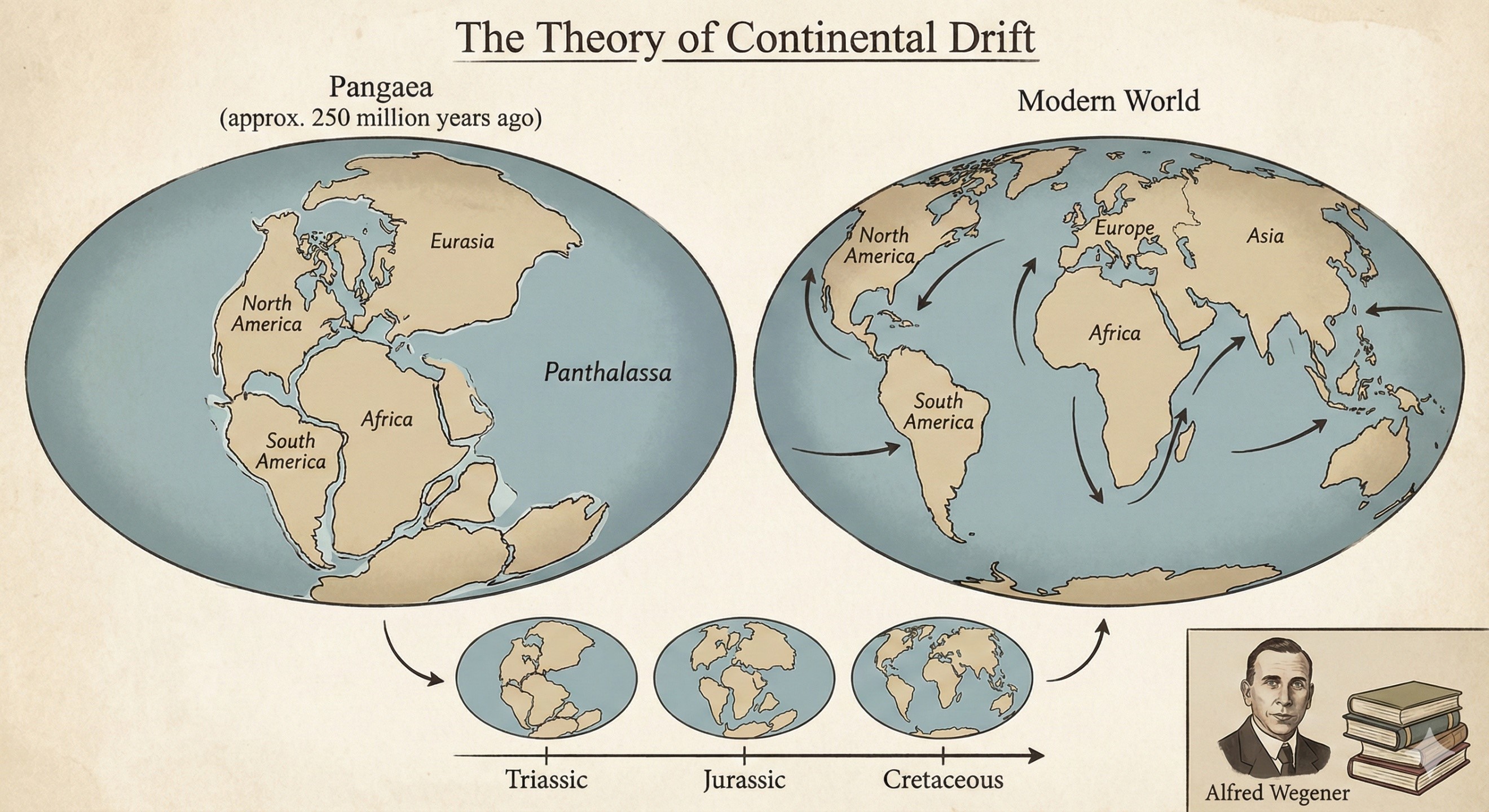
The person who dared to say this aloud was Alfred Wegener, a German scientist who was not even a geologist by training. In 1912, and later in his book “The Origin of Continents and Oceans” (1915), he suggested that the continents are not frozen in place — they move slowly across Earth’s surface. At that time, this sounded as strange as claiming the Moon changes shape. But Wegener had observations in his favour. He noticed how the coastlines of South America and Africa looked like pieces of the same puzzle, and how identical ancient fossils — such as Mesosaurus and Glossopteris — were found on continents now separated by oceans. Even the Appalachian mountains and Scottish highlands share strikingly similar rocks, as if torn apart mid-construction. Glacier marks found in present-day tropical regions also hinted that these places must once have been part of a common, colder landmass.
And yet, Wegener’s work was rejected for decades. His biggest shortcoming was not the idea but the missing “how”. He could not convincingly explain the mechanism that could move such massive continents, and suggesting that Earth’s rotation and tidal forces pushed them did not satisfy the geologists of his time. Tragically, Wegener died in 1930 during an expedition in Greenland — still convinced he was right, but without seeing the world accept his theory.
Then the oceans revealed the truth.
In the 1950s and 1960s, scientists studying the seafloor discovered something astonishing: new crust was forming at underwater ridges and spreading outward, while old crust was sinking into deep ocean trenches. The magnetic signature of rocks on the ocean floor confirmed it like a barcode — Earth’s crust was moving. Researchers like Harry Hess and the Vine–Matthews–Morley team provided the scientific mechanism Wegener had lacked. What geologists once rejected became the missing puzzle piece that led to the theory of Plate Tectonics in the late 1960s.
With this breakthrough, the movement of continents was no longer speculation — it became the backbone of modern earth science. Suddenly, everything made sense:
why India’s northward journey formed the Himalayas,
why the Atlantic Ocean keeps widening along the Mid-Atlantic Ridge,
why earthquakes strike the Pacific Ring of Fire,
and why fossils and ancient climates line up across far-separated landmasses.
Continental Drift was not replaced — it was validated, corrected and expanded. Wegener had been right about the big picture, even though he never found the mechanism in his lifetime.
Today, the idea continues to shape how we understand the planet. The slow but unstoppable movement of continents is still happening — Africa is gradually splitting along the East African Rift, Australia is drifting northwards, and the Atlantic continues to stretch wider every year. In other words, the world map we grew up memorising is only a temporary snapshot of a planet that is always in motion.
Continental Drift is more than a geological theory; it is a reminder that great discoveries sometimes begin as rejected ideas. The world eventually caught up to Wegener — and Earth science was never the same again.
Earth & Geomorphology — Prelims Core Facts
Structure of Earth
- Crust (0–70 km) → Oceanic crust (Basalt) denser than Continental crust (Granite).
- Mantle contains ultramafic rock (Peridotite).
- Outer core is liquid, inner core solid (Iron–Nickel).
- Moho Discontinuity — crust–mantle boundary.
- Gutenberg Discontinuity — mantle–outer core boundary.
- Lehmann Discontinuity — outer core–inner core boundary.
Minerals & Rocks
- Basalt = Extrusive igneous, Granite = Intrusive igneous.
- Limestone → Marble (metamorphism).
- Shale → Slate (metamorphism).
- Sandstone → Quartzite (metamorphism).
- Coal → Anthracite (highest carbon).
- Igneous rocks have no fossils, Sedimentary rocks have fossils.
Plate Tectonics & Continental Drift
- Lithospheric plates float on the Asthenosphere.
- Divergent boundaries → Mid-Ocean Ridges.
- Convergent boundaries → Fold Mountains / Deep Trenches / Volcanoes.
- Transform boundaries → Earthquakes without volcanism.
- Japan & Philippines — ocean–ocean convergence.
- Himalayas — continent–continent convergence.
- East African Rift — continental rifting (future ocean).
Volcanoes
- Ring of Fire — Pacific margin (75% active volcanoes).
- Iceland — Divergent boundary volcanism.
- Hawaiian volcanoes — Hotspot (not boundary).
- Composite / Stratovolcano — most explosive.
- Shield volcano — basalt lava, broad slopes.
Earthquakes
- Focus = inside Earth, Epicenter = on surface.
- P waves travel through solids + liquids, S waves only through solids.
- Magnitude (energy) measured by Richter, Intensity (damage) by Mercalli.
- Tsunami — undersea quakes > ~7.5 magnitude common trigger, not tides.
Weathering & Erosion
- Freeze–thaw = mechanical weathering (cold climates).
- Chemical weathering highest in tropical moist climates.
- Karst landforms — limestone areas (stalactites & stalagmites).
- Meanders & Oxbow lakes — mature river stage.
Soil & Desert Facts
- Laterite soil → High iron & aluminium, poor in nitrogen.
- Black soil → Clayey, cracks in summer, high moisture retention.
- Loess → Wind-blown silt, highly fertile.
- Erg (sand seas) ≠ Reg (stony desert).
Oceanography Quick Wins
- Warm currents on east coast of continents in tropics, but Gulf Stream warms Western Europe.
- El Niño → warming of Central/Eastern Pacific → weak monsoon in India (mostly).
- La Niña → cooling of Pacific → strong monsoon (mostly).
- Neap tides — Sun & Moon at 90°; Spring tides — full & new moon alignment.
Climatology “trap” points
- ITCZ shifts northwards in Northern Hemisphere summer.
- Horse latitudes → subtropical high pressure (30°).
- Westerlies stronger in winter.
- Jet stream guides monsoon onset & withdrawal.
Biomes & Natural Vegetation
- Tropical rainforest — low humus (rapid decomposition).
- Savanna — wet + dry season, grass with scattered trees.
- Steppe — cold mid-latitude grassland.
- Taiga (Boreal) — coniferous forest.
Mapping & Locations
- Mariana Trench — Pacific (deepest).
- Great Barrier Reef — Australia (largest coral system).
- Dead Sea — lowest continental point.
- Lake Baikal — deepest freshwater lake.