

Introduction
The Krishna River is one of the most significant east-flowing rivers of Peninsular India and plays a crucial role in India’s geography, agriculture, hydropower, and inter-state water management. For UPSC aspirants, especially those preparing for Geography and Environment papers, understanding the Krishna River system offers insights into river basin planning, irrigation, regional development, and water disputes — all key topics under GS Paper-1 and GS Paper-3.
This comprehensive guide by Vijetha IAS Academy provides a detailed, SEO-friendly, and exam-oriented overview of the Krishna River — from its origin and course to tributaries, major projects, socio-economic role, and current issues — with simplified explanations to help aspirants grasp concepts easily.
Origin and Course of the Krishna River
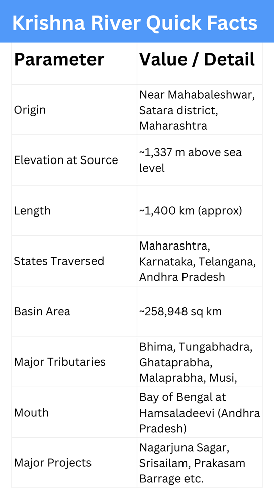
- Origin: The Krishna River rises near Mahabaleshwar in the Western Ghats of Maharashtra, from a small spring close to the Jor village in Satara district.
- Elevation at Source: Around 1,337 metres above sea level.
- Length: Approximately 1,400 kilometres.
- Flow Direction: The river flows eastwards, cutting across Maharashtra, Karnataka, Telangana, and Andhra Pradesh, before draining into the Bay of Bengal near Hamsaladeevi village in Krishna district of Andhra Pradesh.
- Major Cities on the Course: Sangli, Vijayapura, Raichur, Kurnool, and Vijayawada.
The Krishna River is also known as “Krishnaveni”, and it forms one of the most fertile and economically significant river basins of southern India.
Basin and Drainage System
- Total Basin Area: Around 2.6 lakh square kilometres, which accounts for nearly 8% of India’s total geographical area.
- Geographical Spread:
- Maharashtra – 27%
- Karnataka – 44%
- Telangana – 19%
- Andhra Pradesh – 10%
Drainage Features
The Krishna Basin lies between the Western Ghats in the west and the Eastern Ghats in the east. The river and its network of tributaries drain a large portion of the Deccan Plateau, forming deep valleys, waterfalls, and fertile plains as it approaches the coast.
Major Tributaries of the Krishna River
The Krishna River is joined by numerous tributaries on both sides, contributing to its massive discharge and geographical spread.
Right-bank Tributaries:
- Koyna River – Originates in the Western Ghats; known for the Koyna Dam.
- Ghataprabha River – Flows through Karnataka; joins Krishna near Almatti.
- Malaprabha River – Joins Krishna near Kudalasangama.
- Tungabhadra River – The largest tributary, formed by the Tunga and Bhadra rivers.
Left-bank Tributaries:
- Bhima River – Originates in Pune district and merges near Raichur.
- Musi River – Passes through Hyderabad.
- Paleru and Munneru Rivers – Drain Telangana and coastal Andhra Pradesh.
Together, these tributaries create an extensive river network that sustains millions of livelihoods across South India.
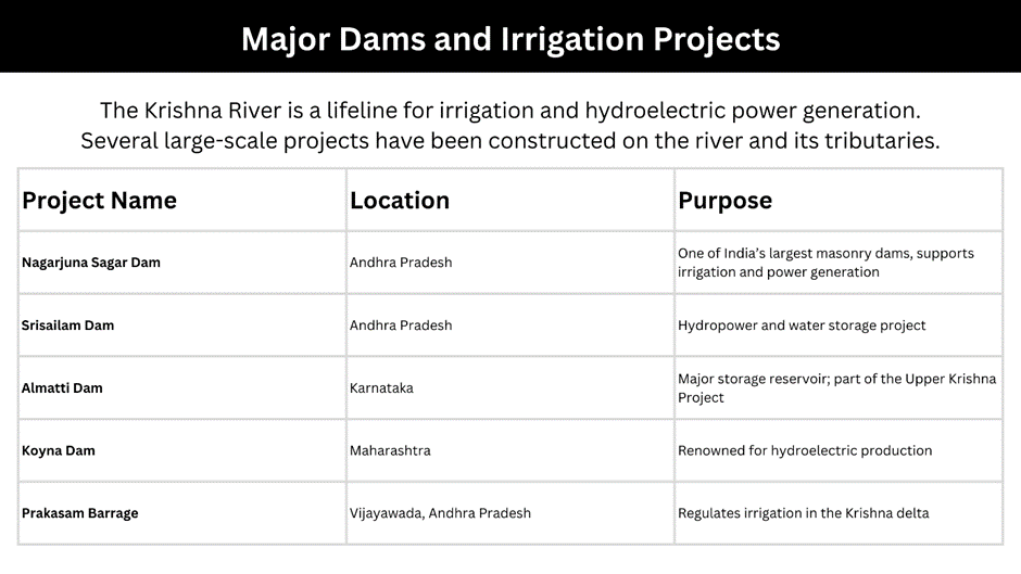
These projects collectively ensure agricultural prosperity in the Krishna-Godavari Delta, often referred to as the “Granary of South India.”
Economic and Environmental Importance
1. Agricultural Significance
- The Krishna Basin supports intensive cultivation of paddy, sugarcane, cotton, and pulses.
- Deltaic regions in Andhra Pradesh are among India’s most fertile agricultural belts.
2. Hydropower and Water Supply
- Several hydroelectric plants along the Krishna and its tributaries generate clean energy.
- The river system also serves as a major source of drinking water for urban centres such as Hyderabad and Vijayawada.
3. Cultural Importance
- The river holds great religious reverence — festivals like Krishna Pushkaralu attract millions of devotees every 12 years.
- The confluence of Krishna and Tungabhadra at Kudalasangama is considered sacred.
4. Ecological Role
- The Krishna Basin includes diverse ecosystems — from forested Western Ghats to alluvial deltas.
- It supports rich biodiversity but faces environmental threats due to urbanisation and industrial waste, especially around the Musi River.
Challenges Facing the Krishna River System
- Inter-State Water Disputes
- Water sharing between Maharashtra, Karnataka, Telangana, and Andhra Pradesh has long been contentious.
- The Krishna Water Disputes Tribunal (KWDT) was established to adjudicate allocation.
- Seasonal Variability
- Being a monsoon-fed river, it experiences uneven flow — heavy discharge in monsoon and scarcity in summer months.
- Pollution and Eutrophication
- Untreated urban sewage and industrial waste threaten the river’s ecological health, particularly in urban stretches like Hyderabad.
- Sedimentation and Flooding
- Siltation in reservoirs reduces storage capacity, while excessive rains sometimes cause flooding in the deltaic region.
- Climate Change Impacts
- Changing rainfall patterns, rising temperatures, and reduced groundwater recharge threaten the basin’s long-term sustainability.
UPSC Relevance – How to Study the Krishna River
Prelims Pointers
- Identify origin, tributaries, dams, and basin states on maps.
- Focus on delta formation, river direction, and drainage pattern.
- Revise topics under “River Systems of India” in Physical Geography.
Mains Focus Areas
- GS Paper-1: River system, basin management, and inter-state disputes.
- GS Paper-3: Water resource management, irrigation, hydropower, and environmental conservation.
- Essay Paper: Themes related to “Rivers as lifelines of civilizations.”
Conclusion
The Krishna River is more than just a geographical feature — it is a symbol of culture, livelihood, and sustainability in southern India. For UPSC aspirants, it serves as a perfect case study for understanding topics like inter-state water management, environmental challenges, and agricultural geography.
By studying the Krishna River system through this detailed guide by Vijetha IAS Academy, aspirants can strengthen both Prelims facts and Mains analytical perspectives, helping them write enriched, well-structured answers in the UPSC examination.